What’s Required by sam taylor

gap
landslide

The past year has been a lot. A lot of uncertainty, a lot of comprises, a lot of hard conversations about the future, our future, and what we want it to look like in the face of these uncertainties. But mostly, the past year has been a lot of change, a lot of change for everyone. Changes in our employment status or what our employment entails. Added difficulty to tasks that were before considered routine, mundane, and aggravating like grocery shopping and filling up the car with gasoline, how incredibly lucky I am to have ever found these tasks routine, mundane, and aggravating as there are so many folks out there who do not have the privilege of a two-income household, a stable partner, and/or a steady income of any kind. And of course the global anxiety associated with COVID-19 and the racial inequities in this country once again coming to a necessary head. Beyond these global changes, Sam and I have experienced some truly substantial personal changes that have added to the pressure of performance in this strange time. And I think he will agree with me when I say that I think we lost track for a minute there, I think we lost track of the thing that makes us keep going. We lost our driving force, our wanderlust, our primal nature to get deep down into a big section of forgotten land and prove to ourselves that we can be brave, tough, and resilient. This is the story of re-finding that force and looking back now, I’m not surprised that it was hiding at the bottom of Smoke Hole Canyon.

Sam and I are loading up the truck. We are leaving after work tomorrow. It feels a little strange to have Sam’s help packing. On most of our adventures for the last several years, I would have done it on my own. Blame it on a combination of my having worked only a few days a week and Sam trying to finish his PhD. But somehow I got used to packing alone, trying to think through all the possible necessities. Charging camera batteries. Checking for headlamps. Water. Food. Camping Gear. Loading it all up and impatiently waiting for Sam to get off work so that we could head out of town. But now, we both have day jobs and Sam is done with his PhD so here we are, packing together. I like it.

cliffs

We are packing for an adventure we’ve been trying to execute for over 6 years. We are trying to get to Blue Rock in Smoke Hole Canyon. Here’s the catch, we are trying to do it over-land without needing a boat or a shuttle and without running into private land. All of the internet says this isn’t possible. The internet says it is too steep, that there are sections of the river bank that are sheer rock that run straight into the water. The internet says all of the routes that are feasible are landlocked by access issues. The internet says it is boat or bust. And while we don’t shy away from the boat or bust adventure, over the last 6 years the dryness of high summer makes the water too low to run and the coldness of the WV springtime leads to Sam, the reptile in our outfit, getting cold feet.

But we’ve devised a plan. A plan to hike down a small and steep drainage to the river and then, stealing a page from the canyoneering adventure book, hike the river. When I say hike the river, I mean we plan to actually be in the water with trekking poles and water shoes, waterproof dry-bags clinging to our backs. The hike is meant to be about 2.5 miles one-way and we are aiming to dedicate a whole day to this one mission. This seems like more than enough time as Sam and I have been regularly running 3 miles in under an hour all summer.

gate

We sleep. We wake up and knock out a few last minute things before we head to work. 8 hours between us and our adventures. We get home and pack the truck to the gills. I make a pot of coffee and fill our travel mugs. Rolling out of town Sam says, “You know how we couldn’t reserve a campsite? I got us one, I sent an email and they called me back. It isn’t fancy but it’s flat and we know we’ve got a spot.” The windows are down and the music is up. “Hell yeah!” I shout back to Sam. The further we get from town, the more I feel the weight of so many months of grinding and pushing lifting off my shoulders.

We do one more weather check before we lose cell service. Rain expected tomorrow starting mid-afternoon. We will have to hustle.

We get to our flat spot and hand the proprietor a 20-dollar bill before setting up camp and cooking a very nutritious dinner of mac and cheese with sliced hotdogs thrown in. We drink beer and talk. We talk about life and COVID-19 and our five-year plan and retirement. We know we want to get up early but we are enjoying the night too much to worry about sleep. We talk for a long time. The sky is dark enough that we can see stars even through the heavy haze that keeps blowing around in the canyon above the trees.

We finally climb into the tent and drift off. We wake up the next morning to our alarm and get moving. Coffee. Breakfast. Pack food for the adventure. Get dressed. Pack up the tent. Rain fly is wet from condensation, lay it out to dry. Get our dry bags organized and ready for the adventure. Pack dry clothes and shoes in a separate bag to leave on the bank before our first river crossing. Drive to the trailhead. Well, not a trailhead really. More of a wide spot. A very specific, predetermined wide spot whose accuracy is confirmed using our back country GPS. Lock the truck. Lock the tailgate. Go.

grade

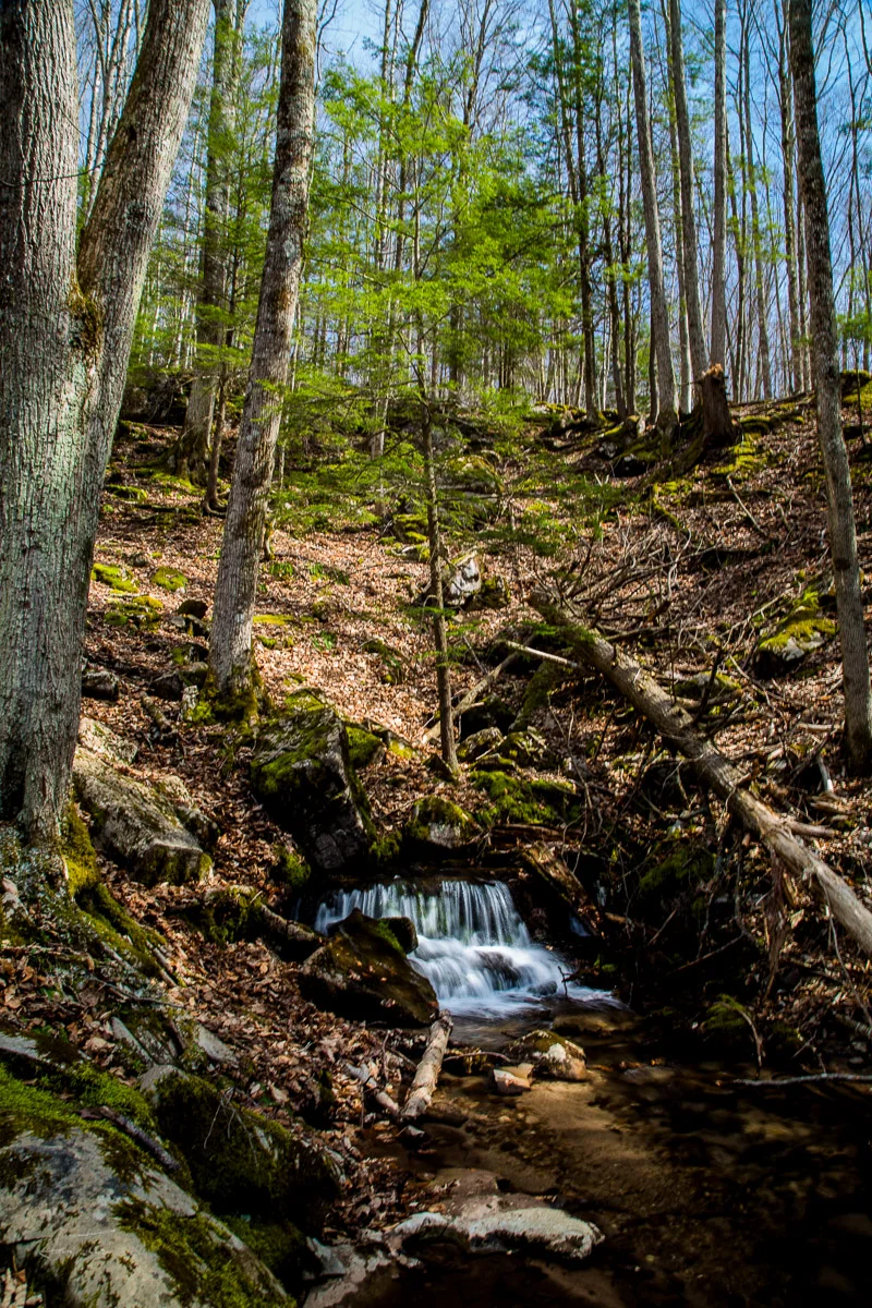
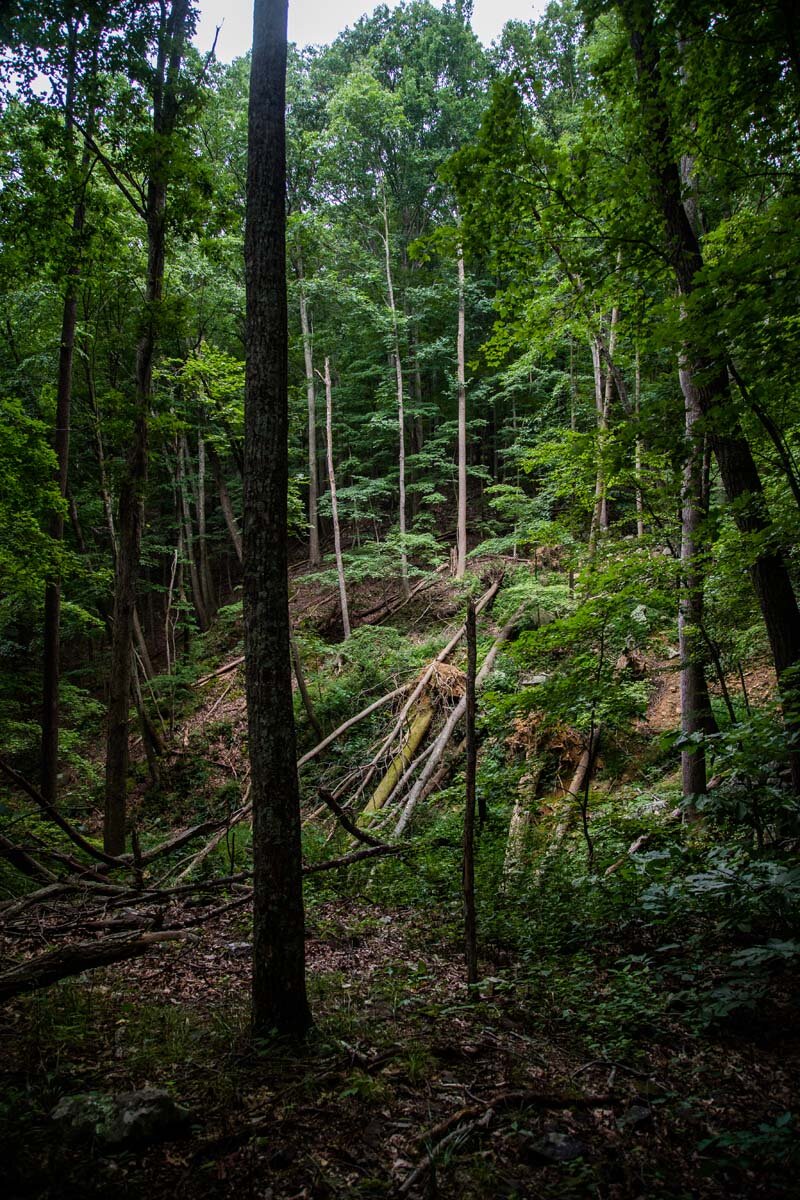
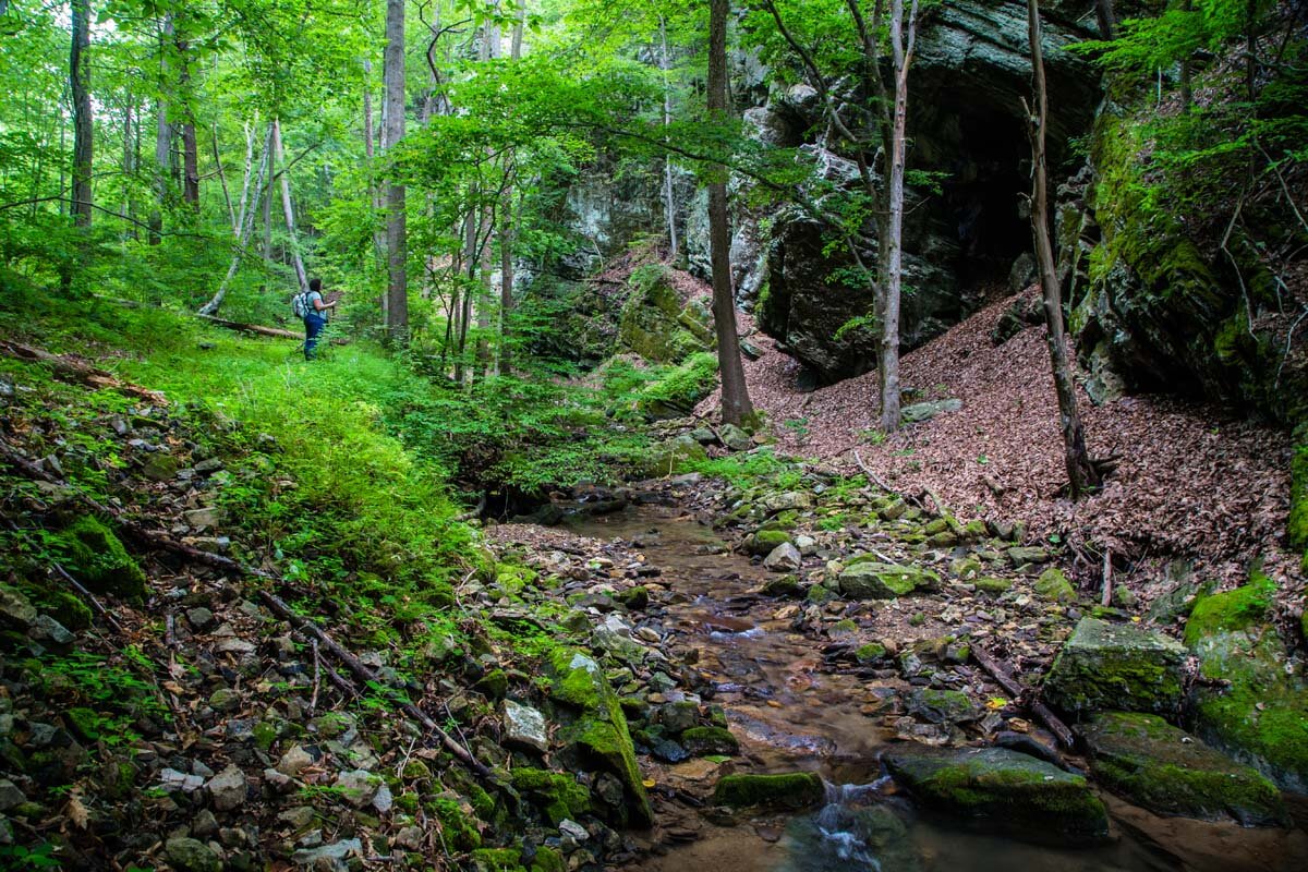
We cross the road and start down into the woods. The terrain is steep and I can feel my body working to control my weight as I walk. We follow an old road grade and I wonder aloud how it must have been back in the days of wagons and horses. Did they have a pulley system rigged up? How did they brake? Sam of course has answers to all of these questions, always the engineer. We follow the grade until we cross the drainage. It is steep but manageable until we come to a small section of earth that has let go of the mountain, slumped and taking several trees with it. I climb up the loose rock and mud and walk right into a spider web. I crinkle my nose and keep moving. It is slick, rocks break loose under my weight and roll down the mountain. Sam waits off to the side and watches them roll by. When I’ve turned and started across the hill again, Sam follows.

We trek down down down into the canyon. Big walls of rock appear on each side of the drainage before we finally break into Smoke Hole and see the water of the Potomac flowing in front of us. There is a large water-filled hole where the drainage joins the river and Sam and I assess our plan. We trade our hiking boots for water shoes, our pants for shorts. I grab our first snack and we do a time check. We started the hike at 8 a.m. It is already 9:30. and that was just the descent. We both snack and start to realize how big our day could be.

We focus on the mission and stash our dry clothes and boots behind a rock. “The sky isn’t inspiring confidence,” Sam says as we take off down a narrow and muddy fishing path on our side of the river, trekking poles in hand. I step carefully, avoiding nettles against my bare legs. I watch for snakes against the wall of rock the earth below me is barely clinging to. I take another step and the mud melts under my feet. I make fast steps and Sam follows until we get to a wider grassy landing, I turn around to see our progress and we’ve gone maybe 20 yards.

samz

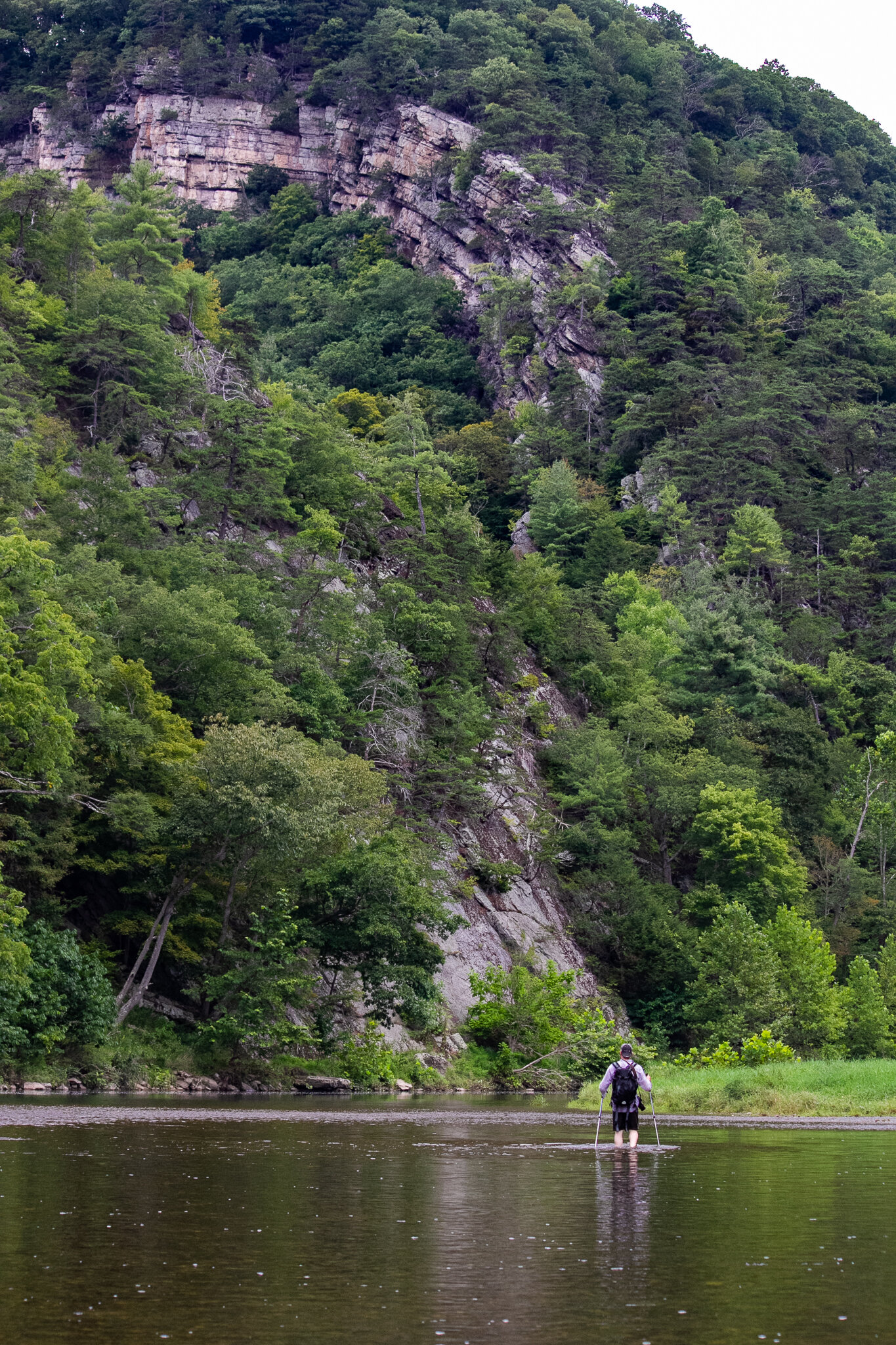
I scan the water from the landing and find what looks like a shallow spot another 40 yards up. We go fast, crashing through tall weeds and god-knows-what until I finally see a somewhat-achievable spot to get in the water. Sam leads us and pauses for second while throwing his arms around in front of him, “Spider web,” he says and we drop down into the cool water. I feel all kinds of unknown plant debris rinse away in the water. For a long time, we work to stay in the river, it is more forgiving than the banks. The current is fast and as we walk up river it makes a lot of noise against our stubborn forms. We press against the water until Sam sees a large landing across the river where we can cut some distance by hugging the bottom of the hillside. We start across and the water gets deep quickly. Every step I feel it inching higher until it hits my belly button. We keep moving and make it to the other bank.

Sam finds another old grade for us to follow, also littered with cobwebs. We make fast work of the landing and run out of ground and find ourselves stepping into the water again. We go for a while and then have to cross to another landing. The water isn’t as deep here and we shove our legs forward, feeling our trekking poles vibrate against the flow. We cross again and we start to see what we are looking for peeking through the trees. The river gets rough here and we climb onto the bank again. There are big piles of driftwood we have to navigate. I am bumbling through trees and thrashing around limbs.

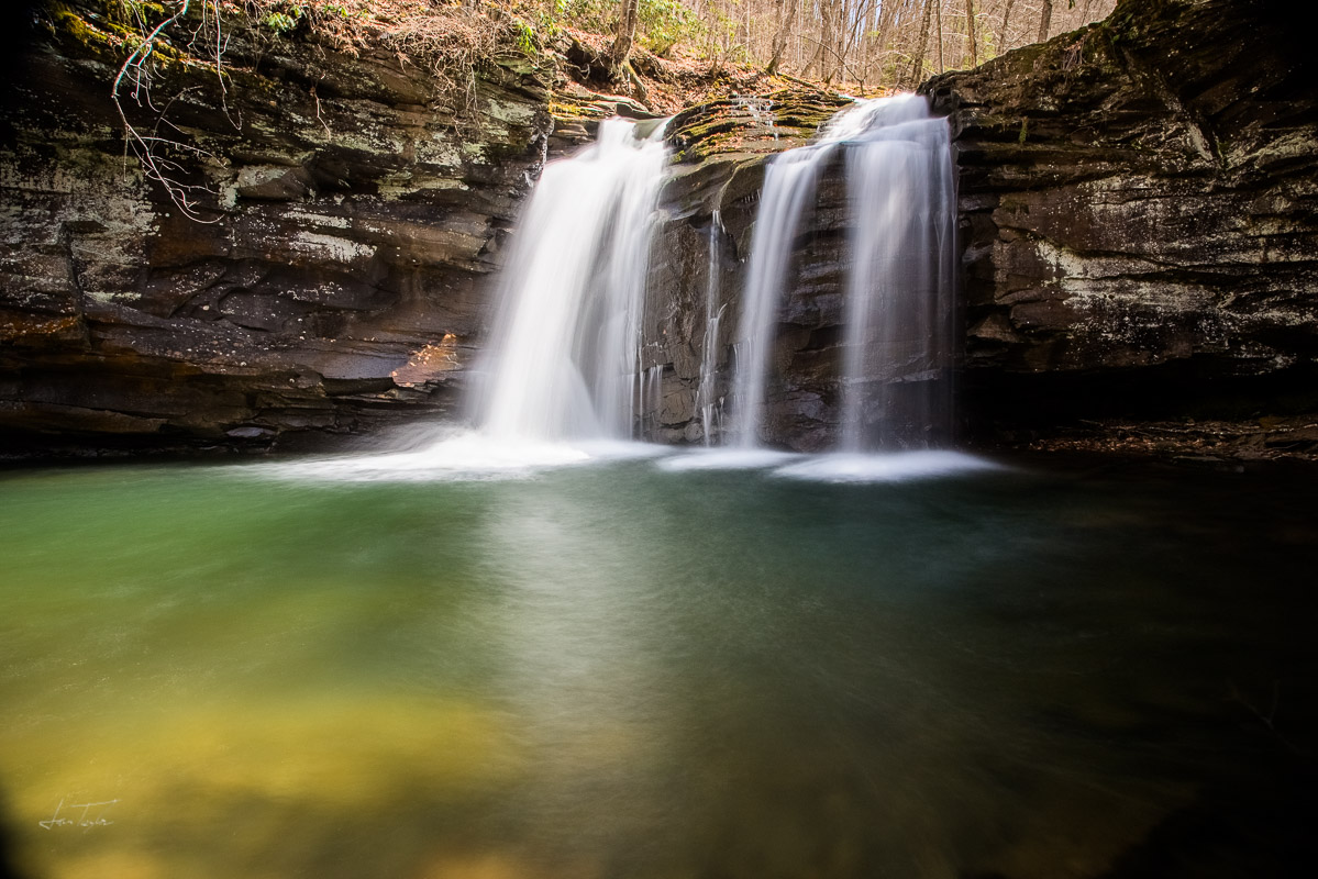
As I climb over the piles and see Blue Rock appear in front of me, I start to cough hard and struggle to breathe. I’m allergic to something in the piles. I look at my clothes and I’m covered in some kind of pollen or mold-like substance. I aim for the fast water above the rough section and shed my back pack before throwing myself in the river and scrubbing at my clothes, coughing and hacking the whole time. What a wild place to have an allergy attack. I get myself gathered up before Sam and I do our final crossing to the giant clear landing below Blue Rock.

After I get to land, I stare up at the impressive wall, one sheer face making up an entire mountainside. We take off our gear and wander for a few minutes. There are cedar trees and wildflowers and butterflies. There is a small fire ring and a few chairs made of stone by humans before us. We eat a snack and drink some water and do a time check. 11:30. We have to keep moving to beat the rain.

blue rock

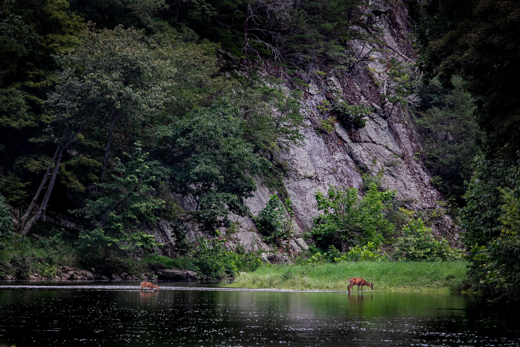
We slide our packs on again and aim for the water. Walking down river is easier, the current helps our legs glide. Having navigated the landings already, we cross them quickly. We keep our cameras out and slung over our shoulders most of the way. Trekking along, Sam spots a doe and fawn crossing the river below us. I lift my camera to my face and work my zoom. I snap several photos. Sam laughs and says, “There, let’s cross right there, where even a baby fawn can make it!” We laugh and aim for that spot. River wide the water is only 6-8 inches deep the whole way.  

deer

We are getting close to the drainage we walked down and will need to make it back across one more time when I start to feel rain drops. Sam goess for the bank but I stay in the water. I work a small rock bar but it slowly gets deeper and deeper. I pause and fumble my camera back into my dry bag. I cinch it down tight. I walk forward and feel the water against my ribs. I see deep blue green in front of me and I know it is going to be hard work to get back across. Sam has climbed into the water now and I can hear panic growing in his voice. I’m the swimmer in this outfit and I go into problem solving mode.

“Sam, take off your bag, tighten all the straps, I’m taking the bags across.” I give Sam my trekking poles and he hands me his pack. I grab both of them by their top handles and stick my arm up out of the water high above my head. I give a big kick and swim hard across, keeping the bags up. I drop them off, shed some layers of clothing and dive back in to get the trekking poles. I follow Sam closely as he swims across. “Keep going Sam, there’s nothing dangerous below here. If you cross a little lower, it is ok.”

limestone

We both make it to the other side and Sam volunteers to grab our dry clothes. We both forgot towels so we air dry first. We eat our last snack and drink some coffee that we stashed. We slide into our warm, dry clothes and I turn and look at the Potomac one last time before we start our climb out. Our lady, the Potomac.

We pump our tired legs up the mountain and come to the grade we walked in on. I lead and take breaks every so often when my legs get too jello-y. Sam uses the time to roll big flat rocks down the hill on their edges, watching them crash through the leaves and seeing how far they will go. We walk and walk, what felt short this morning now feels never-ending. But it is almost good, because I don’t want it to end really. We walk and I spot a big pot of mud in the leaves. I grab a rock and throw it with verve. It lands in a satisfying splat.

We keep going and I see the truck. Determined I say, “I’m aiming for the road.” I turn off the grade toward the road and walk straight into a huge spider web. I laugh and say loudly to Sam, “Spider web!”

We get to the truck, sit on the tailgate, each crack open a beer and check the time. 3 p.m. Sam looks at his GPS trek for the mileage. 6 miles. 6 miles in 7 hours. 1,300 feet of elevation gain. We unpack and choose a direction to head. We climb in the truck and talk about our adventure, both of us knowing already that this is going to be one we always remember. Even if we end up boating to Blue Rock one of these days. Even if we hike this drainage again. We will always remember this one because it was hard enough to remind us that we are brave, tough, and resilient. And right now, that is what the world requires most.

Sam in his natural habitat.

Sam in his natural habitat.

Steep.

Steep.

Packing up camp.

Packing up camp.

Cursed Earth - Canyon Diablo and Two Guns - Arizona by sam taylor

Canyon Diablo - Volz Trading Post Ruins

Canyon Diablo - Volz Trading Post Ruins

Traveling in the West, there are plenty of places with history. Plenty of places that will rep old-west happenings of various repute - train robberies and wagon trails, battlefields and ghost towns, petroglyphs and ancient ruins. We’ve been to many of these places - Mesa Verde, Canyon Pintado, Santa Fe Trail, Rhyolite.

But this place - this place is something else.

I’ve never been to a place that had so much of this history all packed into one, small, area. One spot of ground that has seen drama and tragedy for more than 300 years. This place may be the most intense alignment of all these things that I have experienced - anywhere.

The History of Canyon Diablo

Postcard Image of the Original Canyon Diablo Bridge

Postcard Image of the Original Canyon Diablo Bridge

The geographical feature “Canyon Diablo” is a classic western canyon, cutting across a part of the Colorado Plateau, and is a tributary of the Little Colorado River. It’s a steep canyon, and formed an intimidating barrier to travelers headed west. The name of the place should have been a hint - “Canyon Diablo” was a name given to the canyon by the Spaniards - but the name was apparently based upon Native American superstitions that the canyon was haunted. Maybe they were right.

The first real stories you find about this place center around an incident in the 1870s, where a group of Navajo trapped a raiding band of Apaches in a cave on the banks of Canyon Diablo. They burned the Apaches in the cave - killing 42 of them - as reprisal for the raids. The “Apache Death Cave”, as it became known, is only the first of a series of crazy stories - all within about 5 miles of this desolate place.

The town of Canyon Diablo was initially settled in the 1880s, in support of the transcontinental railroad. In 1880, the railroad “ended” at Canyon Diablo - the last stop - while a bridge was constructed across the canyon. This town became very dangerous, very quickly. According the newspaper in Flagstaff, Canyon Diablo was “more dangerous than Tombstone”, and hosted 14 saloons, 10 casinos, 4 brothels, 1 grocery store, and no law enforcement. After some time, it was felt that the town needed some law - and 6 town marshals would all die in the line of duty - the longest lasting one month. A pretty spectacular train robbery also happened at Canyon Diablo - making off with over $100,000 in currency, 2,500 silver dollars and $40,000 in gold coins - all of that in 1880’s dollars (a little over $3 million in current dollars - not counting any appreciation in gold itself), most of which was never recovered. For a short time, the town had 2,000 residents - but after the bridge was completed, the town died almost as quickly as it had been established. Leaving only the Volz trading post (first image in this piece) and train station behind. But history - and misfortune - weren’t done with Canyon Diablo yet.

Looking toward the town of Canyon Diablo.

Looking toward the town of Canyon Diablo.

Visiting Canyon Diablo

I’ll confess that we didn’t know anything about Canyon Diablo when we first “discovered” it. Our atlas listed it, with the ever intriguing words “ruins” next to it. As we headed into the desert on a road that I wouldn’t recommend you take your rental car on, we gazed across the wide-open desert, searching for signs of… something. After a few miles of “putting the tires on the high places”, we saw trains - great, long, hurtling trains, racing across that transcontinental railroad - they don’t have to slow down for the new bridge.

As we approached the tracks, a train had stopped on a siding, blocking the “road” as it was shown in our map. So we eased up to the bridge, and started looking around. The “new” bridge, built in 1946, is built right next to the original - the foundations of which are still visible. Then, we started to see the walls of what was the town of Canyon Diablo itself. The main thing still left standing is the Volz Trading Post and the cistern behind it. There is still a relatively clear path up to the ruins, which appear to follow the alignment of the original “main street” in town. Rusting cans and pails litter the desert here, scattered everywhere with random chunks of lumber and wire. Things hang around for a long time in the the desert.

The History of Two Guns
Approximately 4 miles upstream of the Canyon Diablo bridge was the site of the aforementioned Apache Death Cave - and, coincidentally, a reasonably moderate place to cross the canyon for settlers and their wagons.

Mountain Lions

This location wasn’t lacking for outlaw history either - Billy the Kid and his gang hid here in the winter of 1879, Eventually the wagon trail became the “Santa Fe Highway”, and a road bridge was built at the crossing in 1914 - and in a few years, the road was named part of the original Route 66. In 1922 a couple purchased land at this spot, and built a store, restaurant, and service station - and the history of Canyon Diablo got a bit more interesting. In 1925, a gentleman going by the name of “Chief Crazy Thunder” (actual name Harry Miller) decided to capitalize on the road and tourists, and built a zoo - “one of every animal that lives in Arizona” - including snakes and mountain lions. He also built a gift shop on top of the Apache Death Cave… and decided to sell the remains - skulls, bones, and the like - as souvenirs.

Ruins on top of the Apache Death Cave, and the original Rt 66 bridge in the background.

Ruins on top of the Apache Death Cave, and the original Rt 66 bridge in the background.

You read that right - he sold the skulls from the Apache Death Cave as souvenirs.

The store burned in 1929.

The alignment of the road changed in 1934, and a new service station was built, but personal tragedies stalked the folks that lived there - leading to the property being bought, sold, and abandoned several times into the 1960s.

In the 1960s, a new service station, rv resort, and campground were built - and it looked like the curse of Two Guns might just be over. Interstate 40 was built, and a dedicated exit ramp was built right to the campground. Things seemed to be going well, until a huge fire consumed virtually all of the town in 1971.

That was the end of Two Guns, deserted ever since.

Visiting Two Guns

It’s not often you get to visit two ghost towns within 5 miles of each other. I’ve traveled quite a bit in the southwest, and every time I have a chance to explore a piece of old Route 66, I do. Maybe it’s a bit of that old romanticism, the “mother road” and such. While much of old Route 66 is romantic, I’ll say that Two Guns isn’t one of those places. Maybe it’s the graffiti, maybe it’s the scale of the ruins - but this place felt unsettling, even before we knew the history of it.

The ruins are rambling - on both sides of the canyon, up and down stream for probably a quarter of a mile - and stretching from the 1900s until the 1970s. The original Route 66 bridge is still standing, accessible. We drove across it (perhaps ill-advised), as we explored. In the older part of town, the buildings on top of the Death Cave were built to look like the ruins at Mesa Verde and other cliff dwellings of the southwest. On the other side of the canyon, the ruins of the original fuel station and zoo still stand - “MOUNTAIN LIONS” painted across the facade of the one building, still facing the old highway.

Kamp

The newer parts of the ruins were the creepiest to me, feeling like a set-piece from a dystopian movie. There is an abandoned in-ground pool, completely covered in graffiti, and its pool/shower house. The view from the pool must have been nice, once upon a time - soaking up the desert sun, the snow-capped top of Humphrey’s Peak rising far off in the distance.

We drove around carefully - nail-studded wood, trash, jagged metal, and…. RV hookups?… littered the scrub brush, and it definitely wasn’t the kind of place that I would have wanted to have car trouble. It felt like the kind of place where something - or someone - might step out of the ruins at any moment.

The last remnant of the campground check-in building is a disembodied roof that reads “KAMP”, standing on a pile of rubble. The taggers have hit it too, at least as far up as they dared to reach without climbing on it.

The fire that hit this place in the 70s must have been incredible. We found melted glass around the ruins (kids that got to put their bottles in fires will know what I mean), and what must have been some of the animal “cages” at the zoo still had chicken wire around them - apparently those cages didn’t hold the mountain lions.

So there you have it. The story of Canyon Diablo and Two Guns, Arizona. I don’t tend to buy into stories about “cursed” places, but the few times I’ve considered it have been in the southwest.

After visiting this place, I may have to revise my opinion on “cursed earth.”

Two Guns

Too Good To Be True by sam taylor

Ok Folks. I’ve talked for years about how we try to “show it like it is”. We go to out of the way places, and try to represent our experiences honestly. Sometimes that is incredible, sometimes we get worked over - but we always strive to be honest about our experiences. For years I’ve complained about “unreal” landscape images. Sometimes, it’s because I went to the place in the photo and was pretty bummed that it didn’t look the way I expected, or the photo totally misrepresented the conditions of a place. Sometimes, its because I’ve had a student or a client that is really frustrated that they can’t make the image they’ve seen online - and they are upset to find out that it “can’t be done” without a lot of manipulation and software.

Straight Out of Camera

I’m going to take some time today to talk about and give some examples of these types of manipulations - and this won’t even get into heavy “compositing”, where parts of different images are assembled to make a new image. Compositing is an art form to itself, one I have a great deal of respect for - but it isn’t photography, and it isn’t what we’re going to talk about today. Instead, we’re going to talk about how to spot images that have been manipulated - and how different it might look, if you go there. From where I stand, this place is beautiful enough - we don’t need to fake it, unless the point isn’t about the place, but about the “likes and shares”.

Fall Foliage

My “Normal” Edit

Every year we travel this state like maniacs - searching out the leaves, chasing the views. Much of the time, I try to use photos I see from around the state to guide my travels. Fellow photographers I know make gorgeous images of Southern West Virginia - and it lets me know whether it’s a good weekend to head south or not. In the last few years, though, it’s been tougher - we’ll see images online that are all orange and yellows, even though it’s green everywhere we’ve been, and everywhere we’ve talked to people. How is that? Well, let’s take a look.

This first image is “straight out of camera”, taken at Holly River State Park. Pretty green. The next image is my “base” edit of the same image, and is the basic edit I apply to almost all of my images. But - it doesn’t look like “fall”! I can’t gain Instagram fame with this image?! The third edit is all in Lightroom - and requires no specialized techniques, just moving sliders. And boy, does this look like a lot of images I saw this fall. Lots of oranges, lots of yellows. But the big giveaway for me? The rocks and water. Other than AMD, we don’t have a lot of orange rocks and orange water in West Virginia. We also don’t have wall-to-wall yellow and orange trees typically in this state. Weird. And I would have been pretty upset for driving 3 hours expecting to see those wall-to-wall colors instead of what was actually there, based on this photo.

Fall Foliage! Sort of.

Fall Foliage! Sort of.

Beautiful early fall day at Seneca.

Oranges! Oranges everywhere! (including in the rocks)

Lets try one more, of another landmark in West Virginia - and one I seem to see every fall, Seneca Rocks. Once again, the top photo reflects my basic edit, the type of image I would post on our page, or share in our social media.

The bottom photo looks lovely, and nothing like most any fall I’ve seen in West Virginia in the last few years - and again, isn’t the product of anything exotic or specialized, just Lightroom. Which one is more likely to get shared across the internet? I have a pretty good idea, but it isn’t real, and if someone took the time to drive there, they might be pretty disappointed with the result.

I think this also speaks to one of the reasons this rankles me as well - fall is a BEAUTIFUL time in West Virginia, but it is also fleeting and elusive. We have years where it’s a little too dry, or a little too wet, or bugs get to the leaves, or the frost comes on too early, or storms come through and knock the leaves right off. It’s hard - and rewarding! - to find these beautiful places, because it doesn’t often set up in wall-to-wall “carpet of color”.

Sometimes the urge is to make it “what we want it to be”, but that isn’t what it is, and it diminishes the value of these things when they actually happen.

Super Moons

Super Moon over Morgantown. 24mm

Another one that I see all the time - especially whenever there is a “Super Moon” - is a rash of cartoonish-ly big moons over scenery. This is a more intentional bit of fakery, and is also hugely discouraging to folks that are learning photography. In general, the moon can only take up a certain amount of the frame in photography. Cropping and such will help a bit, but if you are out landscape shooting, there is only so big that the moon will be in a given frame for a given focal length.

For example, the first photo above is of a full super moon over downtown Morgantown. This photo was taken at 24mm focal length, a pretty common “kit” zoom length for point-and-shoot or SLR cameras. Notice how small the full moon is at that zoom length? Similar to how the moon “follows” you in a car, the moon is big enough - and far away enough - that it is always going to look that big, at that focal length - you can’t get “closer” by walking up or changing compositions to make it bigger. Also - take a close look and notice how you don’t see any stars in that image - but we’ll talk about that more later.

Full Moon from my porch - 250mm

Here is a photo, from my front porch, also of a full moon in the morning. This was taken at 250mm focal length - not a common “kit” length, but folks may have it around, or maybe with “digital zoom” you can get this equivalent focal length.

While the moon is “bigger” in this image, you can see how zoomed in I am on the surrounding scenery. To get the houses in my neighborhood in my frame, I would have to back up - a lot - which in our part of the world (hills and valleys and trees) isn’t always possible.

The Famous Lindy Point at Sunset.

To illustrate this, I’m using an image I’ve taken of Lindy Point at Blackwater Falls State Park. The first image is the original - no moon - taken at 24mm focal length. If you’ve been there, you know that the observation deck limits how far back you can get.

A little moon never hurt anybody! (24mm equivalent focal length moon composite)

In the next image, I’ve composited (added) the moon from the top photo, also at 24mm, into the image. There are probably a few times a year that Lindy Point looks something like this - with a full moon in the western sky, and the moon is proportionally sized to what you might actually see.

But that moon is scary! (250mm equivalent focal length moon composite)

In the third image, I’ve used my “250mm” moon from above. To me this looks terribly fake, and more importantly, there is no way to capture this image in real life. Quite literally, it will never, ever, actually look like this. If that image were taken to capture the moon at similar size, it would look something like the image below.

Would we prefer it to look this way? I’m not sure - I think I would be alarmed if the moon looked that big in our sky. But I have folks ask me how to take pictures like this, and they become very disappointed when the answer is “you can’t, not from there”.

Not as unbelievable as before, but also not the entire scene

Not as unbelievable as before, but also not the entire scene

This seems like a good time to talk about “compositing” - there are a lot of opinions about compositing, and folks that are good at it are true artists. But by definition, a composite means that the image is not a “single photograph”. Some folks will take a photo for the foreground, and then a second from the same place, at the same time for a different part of the image. This can often be well done - and can be used to capture what it actually “looked like” to the naked eye when they were there - but to a new photographer, it is important to note that it would be impossible to do in a single frame.

Other composites (like my image above) aren’t - they take images from different places, and different times, and create a scene which may never even be possible in the real world. For me, personally, I would hesitate in calling this a “photograph”.

As an aside, there are ways to make beautiful “super moon” photos with landscapes in the foreground - but they are very, very difficult to make as an actual photograph, and not a digital manipulation. They require getting far enough back from your subject to fit it all into the frame. Not an easy thing to do, generally - and remarkably hard in a place like West Virginia, where trees, ridges, and valleys all conspire to get in the way of your view.

A nice example of a photo made in this way (and explanation of how) is here: (https://photographingspace.com/moon-silhouette/). To put it in perspective - the beautiful image he describes there took a lot of planning, a 1,200mm lens, and he was standing a little over a mile away from the subjects when he took the photo.

Stars and the Moon and The City (Just Not at the Same Time)

Full Moon over Woodburn - Note Overexposure on the Moon!

Full Moon over Woodburn - Note Overexposure on the Moon!

Last but not least, I see so, so, many “full moon with sky full of stars” shots, and those are almost universally the product of compositing. I’ll give a couple of examples, and then talk about the technical reasons a little bit.

This photo of Woodburn Hall in Morgantown. The moon is over-exposed - no seeing the “man in the moon” here - but it was the exposure needed for the foreground scene. Why is this notable? The foreground was lit, extensively with lights - and yet was too dark to properly expose the moon! The full moon is extremely bright - way brighter than we tend to realize - and can dominate an image as a result.

Also - while there are a few stars peeking through here, note how it isn’t a “sky full of stars”. Why? Because, again, the moon is too bright, and I couldn’t make the exposure bright enough for stars without overexposing the entire image.

For perspective, this is a 1/4 moon!

This is an another example. This image was made in a very dark place (Canaan Valley, WV) - but more importantly, this was a waning crescent moon (2/10/2018). Note, even though the moon was only ~1/4 full, how bright it looks on the ground and in the sky when the rest of the image is exposed for stars.

So why does it seem like we can see these things with our naked eye? The biggest reason is that the human eye can see an incredible range from light to dark at the same time - about double the range of the best cameras.

In big cities, this becomes a very difficult thing because of light pollution. If you are in a city, and can barely see the stars, your camera is going to struggle just as much.

Full “Super Moon” over Morgantown. The moon is brighter than town!

Full “Super Moon” over Morgantown. The moon is brighter than town!

My final example is comparisons of two shots of Morgantown, from roughly the same place (the Westover bridge), one illuminated by a full moon (I used this image earlier), and one without.

No Moon Over Morgantown - See a few stars?

In the image with the moon, I had to make a compromise in exposing the city - the moon was that bright, and would have been way overexposed if I’d been any brighter. In the image with the stars, I was able to go brighter with the city, and pull out the stars a little bit as a result. Even in the starry image, this was getting to the limit that I could expose the city - any brighter would have overexposed the city lights, and it isn’t the “carpet of stars” or “milky way over the city” that I see in some obviously composited images.

I haven’t even started talking about shooting the milky way - we’ll just say that it is challenging to do, in terms of finding dark enough places to really make the image. A milky way image over Morgantown would be technically impossible, as the city lights would overpower the stars - and Morgantown is a relatively small city. Again, if you can’t see it all with your naked eye, it’s going to be tough to do with the camera.

So what’s the conclusion today? Well, I have a couple of goals. Firstly, I wanted to give a bit of encouragement to folks that are learning photography. There may be a reason why you can’t replicate a favorite image you’ve seen on the web, and it might not have anything to do with your camera equipment or your skill set as a photographer. I also wanted to put some light on the “real world” effects that come from these heavily manipulated images - folks make plans, take time off, to go to beautiful places or to enjoy the seasonal scenery, and it can be very discouraging to go somewhere and find that it doesn’t look anything like the photos you saw on the internet.

Lastly, I hope that it will help folks to understand what they are seeing when they see images that seem “too good to be true”. In many cases they are, and I think it takes away from the good - and hard - work that dedicated photographers do when pursuing this art form.

Hope y’all have a great week.

S

Tamarack "May Your Days Be Bright" Opening! by sam taylor

Cast - West Virginia

A bit off schedule, but I wanted to let folks know my excitement at having two images selected for an upcoming show at the Tamarack David L. Dickirson Fine Art Gallery!

The two images, shown below, are titled “Cast” and “November Mood”.

It is always an honor to show at Tamarack, and I hope folks are as excited to see these - and all of the incredible work that makes up these shows, as I am to present them.

The opening reception is this weekend, November 10, from 5-7pm - while we won’t be able to attend the opening this time, we look forward to seeing the exhibit during its run from now through January 6, 2019.

Hope folks have a great day, and thank you for your continued support!

S

November Mood - West Virginia

Thoughts On Fall by sam taylor

Perfect, For A Limited Time - West Virginia

Pumpkin Stuff, Cute Sweaters, Crisp Days

So it’s started.  It starts every year, really, with the start of school.  The “leaf themed” sales at the stores, even though school starts at the beginning of August these days.  It progresses pretty quickly from there.  Some years its Labor Day first, and then, the first not-hot day we have, a bunch of people talking about how it “smells like fall”, or “feels like fall”, or something like that.  Other years, it’s the reverse, but every year it happens.  And every year, I fight screaming at them to keep it to themselves.  That I don’t want pumpkin-anything before October 30th.  I fight a rising tide of anxiety.  A rising wave of regret.  Melancholy.     

Grimes Golden

Grimes Golden - West Virginia

It’s funny how we, as a culture, trend toward stuff that’s new or pretty, versus what’s “good”.  Growing up, we always had one of these trees in the orchard, and I never thought much about it – I just knew it was my “favorite” of the apples to eat.  As with many things, I got older and moved away (and around), and I spent a lot of time buying grocery store and farmers market apples, and never found any that were as good to eat.  Plenty that were prettier, plenty that were bigger, but none that were as good. 

A few years back, I pulled my dad aside and asked him, “what are those called?”.  “Grimes Golden – I think,” he said.  Continuing, “they’ve been here for a long time, so I’m not exactly sure.  I’ve planted a few when the older trees start to decline, just because I like them so much.”  I laughed pretty hard at this – that he didn’t really know either – but his answer was better than mine.  I’d always called them “ugly apples”, because they came off the tree a little rusty, and lumpy, and misshapen – but my oh my were they good. 

I did a bit of research, and I think I agree – Grimes Golden.  According to what I’ve read, they are a parent to the Golden Delicious apple – and a no kidding native of West Virginia, dating back to the 1830s in Brooke County.  This may be my favorite part of autumn.

The Things That Happen

Glory - West Virginia

“Yeah man, that sounds like a hard drive problem, if your computer won't start”, I said. 

“Cool, I think Jason and I will run over and see if we can get one.  You coming in this weekend?”, he said.

“Yeah, I’ll be glad to see you.  It’s been a crazy couple of weeks.  I’m seeing a girl, I’d love to talk to you about her.” 

Sometime the next morning, I was awakened by a phone call.  He was gone.  Car accident.  

My memories of that time are a bit of blur – some of it drunken – but I remember the leaves changing.  Full color.  I remember standing around with my friends.  Peers. Realizing that it was probably all going to be different after that.

I have a photo of it.  One of the most incredible photos of my life – I’m not sure who took it – because everyone is “in” the photo.  Of all of us sitting under the maple tree in my parents yard, in a pile of leaves, all of us grieving in the cool, crisp, fall air. 

I would leave the state within a year of that, with that girl I wanted to talk to him about. 

I’d divorce her a decade later.

Going Hard

Fall truly is the most beautiful season here.  The leaves are incredible, and it seems to be our “dry season”.  Perfect for doing everything outside.  Hiking, biking, rock climbing – they call it “Sendtember” around here.  Everyone is psyched about playing outside – Gauley Season, Football Season. 

We definitely turn it up a notch.  Weekends packed to the gills – take a half-day on Friday, drive out to the mountains, get a couple of mile hike and setup camp before sunset.  Get the sunrise, marvel at the beauty in the leaves changing, in the smell in the air.  Drive through the hills and climb with your friends till dark – which isn’t that late – so you can have a few beers and dinner, and still be in bed before midnight, ready to do it again. 

We push hard, because we know that literally the best thing we’ve seen all year may be just around the next curve or over the next hill. 

But part of me thinks we push hard because we also know time is short.  That in a few short weekends, it will be too dark to hit it after work, and too cold to camp happily.

The Day We Won.  The Day We Lost

The conditions were perfect.  It was dry.  It was cool.  The leaves were on fire.  That’s a great thing about West Virginia.  If you know the state, and watch the weather, you can chase the changing leaves from the high-country to the low-country, and stretch your fall out for a month or more.  We were out on the early part of the change, September – in the top of the high country around Dolly Sods and Canaan Valley.  We had pushed on an epic hike through the day – 8 miles – and returned to base camp with light in the sky – and realizing that it was about to be an incredible sunset.  I motivated Carmen – motivating me too – that we should go for it.  Worst case was an awesome walk in the evening.  We thundered to the top of the ridge, and we made one of my favorite images and memories of the last several years as we crested to an astonishing sunset over the mountains.   We rallied back to camp, and had a great evening with friends in a perfect Autumn night.

The next day, it felt like the wind was at our backs, that we could do no wrong, and we pushed on toward a spot that we had found earlier in the summer, and were sure we should return to.  It was an epic campsite, on the spot of a long-gone firetower, but the views were nearly 360-degrees, and we had an incredible night as a couple, dancing like pagans around a fire, watching the stars wheeling through the sky.  We arose the next morning, realizing that we had been pushing hard.  That we were tired, and we decided to make a dog-leg past my parents house.  Worst case, we’d get a delicious dinner out of the deal, and then have a mellow drive home on the interstate. 

We got there mid-day, and had some food, and then the phone rang. 

“There’s been an accident, no one can tell me what happened, but we have to go”

We got there, and our worst fears were realized.

Over the next week, I saw the best in people.  I sat on the porch, shivering in my flannel, as the weather moved between Indian Summer and cold fall rain.  And I realized it was going to be a long winter. 

tbd

 Ironic and Irrational

In the end, it will be ironic to me if what ultimately causes me to leave this state isn’t economic or environmental woes, or regressive politics, but the fall and winter.  It isn’t fall’s fault – but I know what it means.

It means me staring my own mortality in the face.  It’s me feeling like I have a set number of years left, and I’m about to spend 3 months sitting inside, waiting around in the dark and cold for something to change.   Trying to stave off my aging through another season so I can get back to what I love again. 

Because to me, Fall is waiting around for something bad to happen. 

Because to me, Fall is like watching something I love die.  Every year.

Because to me, Fall is making a plan to waste time.

One day, maybe, I’ll leave this place, and I’ll only see Fall when I want to. I’ll be able to see the leaves and smell the air and know, like the migrating birds, that it’s time to get the heck out of there, and spend the cold and dark months somewhere warm and light and not wasting time. Because I know what it means, and it’s later than you think.

Never Been by sam taylor

Text By:  Carmen Bowes

Photos By:  Samuel Taylor

From The Cities We Fled - West Virginia

Sam and I have traveled West Virginia, we’ve deeply traveled it. We know the backroads from Rupert to Carrollton to Circleville. We spend whole days taking the backway, going 5-10-15 miles an hour, just in case there’s a waterfall we haven’t seen or an old homestead on the top of some old ridge whose fields we haven’t gazed upon before. WE TAKE OUR TIME. If there are antique roses blooming messily over some fence line, we stop to smell them. We’ve bought cheap coffee from the Liberty gas station in Mt. Storm, from the Quickstop in Albright, and from the Marathon in Greenbank. We’ve eaten at Custard Stands and Dairy Queens and small-town, cinderblock diners. We’ve been all over this state, I would have said most of it. But a few weekends ago we sat down at the breakfast table, laptops out, and we found a couple days’ worth of new roads, new overlooks, new creeks, new campgrounds, new everything, completely new to both of us. Here’s how it went.

I run up the stairs and throw a bunch of clothes in my overnight bag. Raingear, swim gear, hiking gear, sandals, boots. Then I pack Sam’s overnight stuff. I run back down the stairs carrying too much on each arm and see Sam out in the driveway checking the pressure in the tires on the Jeep. I run up and down the basement stairs a few times, each trip bringing some piece of camping gear with me.  I go to the fridge. Beer. Food. Water. I zoom around the corner to the living room. Camera gear. Batteries. Headlamps. Tri-pods. Backpacks. Machete. Hatchet. Lighters. I’ve done this packing list so many times it takes almost no thought.

Feeling Our Way

Sam comes in the door. “Jeep’s had a once-over. Everything looks good.” He says.

“Everything should be ready. Go ahead and start hauling stuff.” I say back. We pack everything into the hatch. I add camp chairs and our WV atlas. One last check around the house for anything we might have forgotten, and we pull out of the driveway and out of our neighborhood. We drive 705 to 68 headed east, way east. We’re going to a place called Wolf Gap Recreation Area somewhere just this side of the Virginia Line. There’s a campground and an overlook but the weather looks iffy. We’re going anyways.

We go through Friendsville and Deep Creek and Gormania. We take 48 through Baker and Moorefield, it’s raining and the sky looks temperamental. We stop at an overlook on the side of the highway. It’s alright but the thistle and the chanterelles are more interesting.  These are all places we’ve been too many times to count, but on the other side of Wardensville, WV we pick up fresh roads when we turn south.

We pass pretty old farm houses and drive into the national forest. A creek follows the road and we get views of it as we drive. We go several miles and then we see the sign for our stop. We turn in and drive around the loop of campsites. There is a woman and a kid sleeping in the back of a Mustang, a little odd, and a few families with tents set up. Some of the sites look unoccupied but we stop back at the front and read the information board. Camping is free, we fill out a card and mark a site. There is a single spot with cell reception, only about 5 feet in diameter. Sam finds it and looks up our weather. We are going to get rained on, so we rig up a tarp and make dinner.

Camp Dinner

We eat and talk about life and our year and how busy it will be. We talk about how happy we are to be sitting under a tarp eating dinner in the rain in this new place in our state, even if it just means we’ve found a spot for the future. We sit there for a long time. A few hours go by, the rain has slacked off and a heavy fog has rolled in. It’s the kind of fog that makes you afraid to take 3 steps out of your campsite for fear of getting taken by the monsters or never finding your way back. I stand up to stretch for a minute and Sam asks, “You think you’re getting ready for bed, Hotrod?”

“Not at all,” I say. “I’m wide awake, I think I’ll just lay there if I try to go sleep right now.” I put out my arms and lean back to stretch, and realize I am looking up at a clear sky. The stars are peaking out from the trees, they are shining at me through the layer of fog. “Sam, the fucking stars are out!” I say to him, totally and completely astonished.

“Are you serious?” He says back as he stands and comes out from under the tarp. “I’ll be damned, there they are!”

“Sam, we should go somewhere to shoot them, where should we go? We could go down the road to Trout Pond?” I ask.

“What about that trail that goes up the mountain from our campground? The sign said it was a mile and change up.” He says back to me.

I look at his face, the lantern barely lighting it. “Are you serious? You want to hike to the top of the mountain in the middle of the night in the fog?” I ask.

“You wanna do it?” He says back to me. I’ve never been good at discretion and from my time with Sam, he hasn’t either.

“Yeah! Let’s do it!” I say as I walk towards the Jeep. I gather up our gear and we walk out of our campsite into the thick fog. It’s so thick the light from our headlamps reflects off the water particles in front of us and makes us squint.

We take turns leading. The trail is wide and well-trafficked. It is desperately humid and even though the air is cool, we are quickly soaked with sweat from walking the steep grade. Our hearts are thumping as we make our way out of the fog and start to gain the ridgeline. Our trail shrinks but we follow without trouble. A rock outcrop meets us and I scramble to the top. The lights of a small town create an island in the valley, cars wind around it in the dark expanse. “Sam, come up here!” I say. He climbs to me and starts contemplating what city it must be.  

“Front Royal?” He says. “Yeah, that’s gotta be Front Royal.”  

I sit on the damp rock with my headlamp turned off. There is no light except for Sam’s camera and the town out there, sleepy and far enough away to let us feel wild.

We stay there a long while and then we put on our backpacks and walk down the mountain back into the fog. Sam set’s up our platform in the Jeep and we brush our teeth and climb inside. We get tucked in and we sleep good sleep. In the morning it is raining so we just stay in there, cuddled up, listening to the drops fall on the metal above us. It eventually quits, and I put on my boots and plant my feet on the ground. Soggy. I walk over to the tarp and I make us camp coffee to sip it as we pack up. The sky is gray as we turn and head to Trout Pond.

“You know Trout Pond is the only natural lake in West Virignia?” Sam says to me. “Golden Horseshoe coming in handy again!” He says with an ornery grin all over his face, knowing full well he is the nerdiest of the nerds.

“Woah!” I say back, followed by a conciliatory “Cutie!”

Trout Pond Reflection

We drive the 14 or so miles from Wolf Gap to the lake. Pulling into the park there is a bit of confusion, we find another lake in the same complex. Rock Cliff Lake. People are swimming at a small beach area. There is a path that follows the edge of the water. It is a beautiful place, but we want to see Trout Pond. A map in the lot helps us gauge where we are meant to go, we realize we already passed the thing. “How in the hell?” I say.

“This thing must be tiny,” Sam says a little puzzled. We drive around the park for a few minutes until we see a sign that says, “Trout Pond this way,” with an arrow. We park and follow a social path. It leads us to a little tiny body of water. Warnings hang on a fence that stands between us and the lake, “Caution, Sinkhole, Don’t Cross Fence.” We follow the path to a break in the trees and get our first good look at the bowl. The water is still. The reflections of the trees on the other side are crisp.

We walk further around until we get to a small observation deck. A man sits with his two daughters, each of them is holding an individual fishing pole. “Are there fish in there?” Sam asks the man.

“Oh yeah, there’s plenty.” He says back.

Sam smiles really big and says, “Cool man, y’all have a good day!” We walk back towards the car and cross Trout Pond Run, the creek that flows into the sinkhole to create our little lake. It is small and unremarkable for the most part. Unremarkable except for its glassy collection pool, water particles seized by the earth.

We leave that place like so many others we’ve left in this state, amazed that we’d never been there before; amazed that there weren’t 100 other people there with us. We drive away, amazed there weren’t businesses just outside of the park cashing in on tourists. We aim for our house in Morgantown, amazed that it is all ours. All ours, except for the man fishing with his daughters, and we’ll share with them.

Thoughts on "Wilderness" by sam taylor

Camp Site Epic - West Virginia

Good Friday Morning! 

As I briefly alluded to in the Seneca Creek writeup the other day, there were a lot of people on the trail with us.  (haven't seen that trip log?  http://www.samueltaylorphoto.com/blog/2018/4/23/seneca-creek

Zion Narrows Wilderness

Zion Narrows Wilderness

While it was nice to see so many people enjoying their public lands on that fair, spring day, I'll admit a bit of conflict over the amount of foot traffic and camping that I was seeing along the stream.  Part of the attraction of wilderness and backcountry and roadless areas is that you can "get away" from the crowds, and have an experience - an experience in nature - self-reliant.  This has been a conversation I've had with folks about other wilderness areas in the east, notably Dolly Sods and Shenandoah National Park, both of which have become so busy and crowded with folks traveling out from the DC metro that it can be difficult to find a place to park on fair-weather weekends.  At what point does the crowd make the "wilderness" designation moot?  How many people can you crowd into a place, and it still be "wilderness"?

This isn't an abstract conversation to me, because on our travels across the country last year, and in the state over the last few years, there are several places at risk of being "loved to death". 

Must be a wildflower, comes up every spring.

Must be a wildflower, comes up every spring.

Gridlock on the road in Yellowstone.  Waiting in line to rock climb in the New River Gorge.  Full campgrounds in Zion, crowded spots along the Williams River in fishing season - and while many of the people are conscientious, that wear accumulates.  Add in a few "bad apples", leaving trash and building huge fire circles, digging plants or cutting trees and squatting campgrounds, and the impacts become unsustainable.  Add in that park budgets for maintenance and repairs are low, and seem to be on the chopping block every year, and it's easy to see the impacts.

And still the demand for public lands increases, as private lands become off-limits to recreational use, and growing urban areas and folks moving to urban areas leads people to seek the woods and the wilds of this country of ours. 

What to do about it?  That is a surprisingly hard question to answer.  I have my own opinions, for sure, and have done a fair bit of research into the topic, but none of those answers are popular.  In West Virginia there was a push to have admission fees to the parks, which would bring much needed revenue for maintenance - and was hated by the public and never introduced.  There have been ideas for permits or permit lotteries for some of the bigger national parks - but those are also unpopular.  West Virginia has a law that limits liability - liability often being cited as the reason folks post property - to landowners who allow people to use their land recreationally, but still the signs and painted blazes pop up every spring.  (see WV Code Here:  http://code.wvlegislature.gov/19-25/).  Folks carving out their bit of wilderness to keep everyone else off of it.  The prevalence of posting is especially frustrating to us because in many cases there is no contact information, so there is no way to secure the "written permission" that the state requires legally - and I suspect that in many cases, that is intentional.

At the end of the day, I worry that it will all become a "tragedy of the commons" - where too many people take advantage, but don't want to pay for it, and the folks that can buy or rent their own will do so to get away from the crowds.  This is especially troubling for me, where we have a state that struggles with health outcomes and mental health outcomes - and getting outside, getting exercise, and being in nature, can help.  That's something this little outfit is built on, trying to inspire folks to come out and have their own experience; but it is also "for" us, and for our enjoyment - and I need that solitude. 

At a minimum, I hope having a conversation will make folks more aware of the impacts they are having, and maybe they will think differently about needing to clear a huge place for a camp, or about needing to dig that trash bag full of ramps, or about how that little bit of trash "won't be noticed".   It may also provide a bit of inspiration for us - we tend to consciously avoid taking pictures of "people" in our travels, if they aren't part of our group - but maybe that is exactly what I need to do this season, take photos of the "surrounds", and document the places that are busy, and the places that aren't. 

All of this, and I haven't even touched on the Supreme-Court-Case-Waiting-To-Happen that is "who owns the creek in West Virginia". 

Stay safe and be respectful out there. 

Am I trespassing here?  What is navigable?

Am I trespassing here?  What is navigable?

The Sweet Spot: Hiking Seneca Creek by sam taylor

Seneca Creek Trail

Seneca Creek Trail

In our time exploring and adventuring around West Virginia, we occasionally come across a trip that, for whatever reason, escapes us.  A trip that we talk about, plan for, and just can't... quite... get done.  This is a story about us finally experiencing Seneca Creek, a trip that we had talked about for more than 4-years.  Seneca Creek is nearly 20-miles long, and rises on the flanks of Spruce Knob, deep in the Spruce Knob-Seneca Rocks National Recreation Area.  It flows through the Seneca Creek Backcountry, a roughly 24,000 acre roadless area bounded by Gandy Creek to the west and FR112 to the south and east.  You read that right - roadless.  To experience and explore the trip described here, you can't get there by car.  Perfect for us.

Campsite along Gandy Creek

Campsite along Gandy Creek

Getting Close

As mentioned, we had talked about this trail for years - so what was the holdup?  For starters, the top of Spruce Knob is close to... nothing.  It's a full 3 hours from our home base in Morgantown, which meant that we had to find a full day to accomplish this trip - no driving down the morning of, and knocking it out.  Secondly, our main destination on this trip was the Upper Falls of Seneca Creek - more than 5-miles, one way, from the trailhead, with multiple creek crossings along the way.  This meant that we were looking for a rare combination of conditions - plenty of time, good weather, and enough water in the creek to show off the waterfall, without having so much water as to make the crossings dangerous.  We got our perfect conditions at the tail end of an oddly-delayed spring in April 2018 - a warm day, with good flow, and a completely open weekend - a sweet spot for an adventure that we had waited a long time to attempt. 

We headed down on a Friday evening, and found camping along the Gandy Creek - still 30 minutes from the trailhead, but close enough to make our single-day hike possible.  The sites along Gandy Creek are beautiful, and we enjoyed our first night of camping in months out under a starry sky, talking over the campfire and listening to the creek rushing beside our campsite.  The white noise from the water lulled us to sleep, leaving us rested up for the next days hike. 

Railroad Grades, Springs, and History

Getting up the next morning, our drive to the trailhead took us past Spruce Knob Lake, which was very busy with fishermen.  Arriving at the trailhead, the parking area was full - a surprise to us, but we decided that we were going to go for it regardless.  The Seneca Creek Trail is the main artery through the backcounty, the primary trail that follows the creek for nearly 12 miles, which helps explain its popularity.   We decided to "lightweight" our packs - committing to getting in and out in one day, but did take plenty of water and a camp stove and meal to tide us over at the halfway point.  Additionally, we made sure to take our water shoes, and one of us (Carmen) remembered to take their trekking poles.  We set off in mid-morning sun, excited for our day. 

The upper part of the trail is one of the most beautiful, and un-characteristic hikes in all of West Virginia.  The trail follows a turn of the century railroad grade, and was pleasant walking in good conditions for the first few miles.  It winds slowly through hemlock and pine tunnels - a rarity in our fairly temperate state - and the smell and sound of wind through the trees had us refreshed and invigorated as we started down the trail.  At about the second mile, we encountered our first "real" creek crossing, and swapped our footwear.  We swapped back to boots on the other side, and headed for the first major landmark on the trail, Judy Springs.  

Judy Springs

Judy Springs


Judy Springs Campground

At roughly mile 3 from the car, you enter the field at the Judy Springs Campground.  From what I gather, this campground was a logging camp, long long ago, and was converted to a forest service campground, accessible by car up until the 1970s.  These days, it's a lovely, wideopen area, and a common overnight spot for hikers looking to take a couple of days in Seneca Creek.  When we arrived, there were several tents and people scattered around the clearing - these were the first campers that we encountered, but they would be a steady presence from Judy Springs on down.  

Judy Springs Campground is named for Judy Springs, which rise just above the campground and flow into Seneca Creek at the campground.  These springs are a significant tributary in these upper reaches of the creek.  It's a surprising scene, to see a stream rise, fully formed, from under the mountain.    

Continuing past Judy Springs, the trail became more challenging and rugged - a short distance from the campground, we encountered our second ford of the day, and switched to water shoes for the next several miles.  The creek and the setting are incredibly beautiful in this section - cascading over rock ledges, reflecting the rhododendron, and teeming with trout that are visible from the trail.  There are distributed campsites all along this portion of the trail, all of them in beautiful positions near the creek - and every one of them seemed to be occupied as we walked down on a Saturday morning.  After a bit of a rock scramble, we encountered our third creek crossing, and then a fourth.  As we reached this lower end of our hike, we met several hikers headed back up the trail, and finally reached our destination - the Upper Falls of Seneca Creek. 


Upper Falls of Seneca Creek

Upper Falls of Seneca Creek


Waterfalls with Friends

As we crossed the creek for the last time on our descent, we really caught view of the trail's railroad history - the trail parallels a trestle base at the top of the waterfall.  As we crossed the creek, we realized that a whole church youth group was swimming at the base of the falls, truly impressive to me, as my feet were tingling from the cold water on our crossings to this point.  We set up the camp stove, and boiled water for a warm lunch, while watching the kids play at the waterfall.  We took note of some long sections of railroad rail in the creekbed, and I wondered how long they had been there, and if they were washed there from a long-ago flood, or were just tossed there when the trail was constructed. 

I didn't have too much time to further think on this point, as the food was ready, and the kids were starting to pack up, and we ate a well earned - and as it would turn out, well needed - meal, and set up to photograph the waterfall. 


6 miles and 1,000 feet

One of Eight Creek Crossings

One of Eight Creek Crossings

With a reasonably full belly, we started the trip back to the top.  We did this hike as an "out and back", so we retraced our steps, photographing things along the way to help slow the climb.  I had estimated the journey at 10 miles round trip, but my hiking GPS put us at 6 miles to our turnaround point at the waterfall - meaning we were going to have a pretty big day.  We left the waterfall, and met more hikers headed in for their dose of wilderness.  As we hiked along, we talked with folks camping along the creek, including a large group that had set up a solid looking base camp, ready to spend a week by the looks of things.  After a couple of miles, and repeating the lower creek crossings, we returned to Judy Springs, and did this short side-hike up to the spring itself.  Feeling adventurous, we drank straight from the spring (repeat at your own risk!), and Carmen added to her experience - having a little slip, where she did her best to fall headfirst into the spring.  Uninjured, we picked up and continued, chewing through the 6 miles, and 1,000 feet of elevation gain from the falls.

By the upper reaches of the trail, we were definitely starting to fade - and started to understand why most folks break up this hike into a couple of days, versus the single day push we were working on.  Even with our fatigue, the trail never lost its beauty, and stayed inspiring and beautiful all the way back to the car.  


Bringing It Home

Reaching the parking lot, we were hungry, weary, and happy.  The GPS said we had covered 12.2 miles and roughly 1,500 feet of elevation gain, with a total of 8 creek crossings - not a bad days work, and more than I would have guessed in walking an old rail grade.  Overall, the hike was a gem, through beautiful country, even if it was a bit more crowded than I had hoped or expected.  In honesty, it's easy to see why this is popular trail, right in the sweet spot of pleasant hiking, beautiful campsites and beautiful scenery, while still letting you feel like you've "earned it" when you reach your destination.  I hope that we don't wait another 4 years to return. 

Route Map - 12.2 miles measured out and back

Route Map - 12.2 miles measured out and back

Upper Trail Evergreen Tunnel

Upper Trail Evergreen Tunnel

Unnamed Tributary of Seneca Creek

Unnamed Tributary of Seneca Creek